|
|
||||||||||||||
|
COMANCHES ON THE FLY SFO TRIP RETURN By Mike Dolin Homeward bound: In the previous article I mentioned a change in plans, by moving 04 Pop to another airport in the Bay area for convenience. It seems we aviators are ready to change plans on the fly, so to speak. It mimics the old adage, "If you have time to spare, go by air." Another plan to go awry was a lunch visit with my cousin in the LA area, whom I hadn't seen for years. We agreed to meet in the vicinity of John Wayne airport in Santa Ana. Then I'd fly on to see my sister in Arizona later in the day. When I called ahead she had another priority, preempting our visit. Bummer. So it's off to Prescott, AZ next. This should be no great problem, except I had to replan my route out of the busy SFO bay area.
The blessing of portable COM: During this trip, my handheld radio, the old bulky KX-99 got plenty of use. In fact, I got an alkaline battery pack for it just before I left. The new pack takes a handful of double-A batteries that last a long time. The rechargeable pack is sure to go dead without notice when you least expect it. In fact, so bad were the rechargeables that I didn't realize how bright the keypad lit up until working on a set of fresh AAs. For each IFR flight, I usually call first on the KX-99 before engine start to pick up my clearance. The benefit is that waiting through the IFR delay isn't so annoying when the engine is off. Because the enhanced class B rules were still in effect (October 2001) I filed an IFR flight plan from Hayward (KHWD) to some little airport outside the "restricted" zone adding the remarks that I would cancel IFR when leaving the east side of class B. "Ground, this is Seven-Seven-Oh-Four-Pop, IFR to Byron." "Oh Four Pop, clearance on request." I waited for an answer. The delay was so long that I called back after an extended period and asked, "Ground, is this radio still working?" Yes it was. "We'll request the clearance again," a pleasant voice replied. Now, how can anyone be perturbed with such a sweet answer? After a few more minutes the pleasant voice rapidly read off the most god-awful clearance to go from Hayward to the edge of class B airspace that you could ever imagine. Essentially I got some bizarre routing to see all of San Francisco that I had missed in the past few days. Seeing that they might be sending me to Oakland VOR, I called back and mentioned that I just wanted to get the hell out of the enhanced class B and couldn't they merely give me a simple vector? The lady in the tower was nice, commenting that this clearance is standard, but the routing you get is always different. Thank you. Engine start. Ready to taxi.
The wayward Hayward departure: Following the taxi clearance, I found myself taking off to the west on a flight going eastward, in calm air when it doesn't matter which way you take off to the pilot, that is. I should have asked for the other end of the runway for departure. You never know if you don't ask. After receiving the IFR release, I took off to the west, flew through wake turbulence of a 727 in plain sight, circled left to the southeast and received vectors around phantom traffic or sensitive areas on the ground that I couldn't see. There must be a method to their madness but it wasn't obvious. I spent an awful lot of time in the air to go just a few miles to the east. On top of that, no less than 4 GPS units quit suddenly this Monday morning. All weekend long, from the Friday arrival to the Harris Ranch flight, plus all the time spent in the Bay area, the 295 worked perfectly. It must be jamming or interference, but I get little support for my claim. When the GPS units finally recovered, all the satellite bar graphs come back with a bang. If that's not interference, tell me something else convincing. Company engineers say the panel mounted TSOd boxes are less susceptible to interference. This is little comfort when the only ones I have are portable. Don't sell your VORs just yet. Upon exiting the class B airspace, after ATC release, I went to LIDAT intersection. Spell it right or the GPS takes you to Hawaii. From there I traveled along the Nevada/California border to an intersection just south of Las Vegas called CLARR, if you're following along on a map. Again, I couldn't fly over the Las Vegas class B due to the current restrictions du jour. When I turned the corner east of CLARR, again the GPS shut down. With no satellite coverage all the way from Las Vegas to Kingman, AZ., I flew the old reliable VOR backup system. Remember how? I was sure glad to have them. There are very few NDB (ADF) stations out there in the mountains. Just to ensure that I wouldn't be having a good day, the bumps continued from the desert to destination, no matter what altitude. Prescott, AZ is one busy airport, with a big flight school located on the field. The chatter on the radio seemed continuous. With a standard landing clearance of "follow that airplane" the lack of any delay was most welcome. It might have been that I was too busy flying the plane, avoiding Area 51 or annoyed by bumps to write notes on this leg as I did over Utah. The mountain and desert scenery is pleasantly beautiful, but I have nothing recorded for this long 5-hour leg. Perhaps frame of mind, I'm less excited now than on the westbound flight. Add to that, I'm never happy when riding in turbulence. I prefer boring smooth air for the entire leg length.
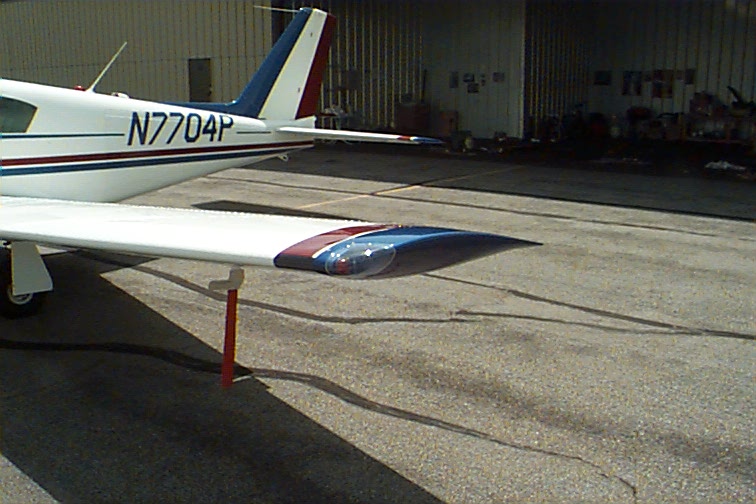
Mountain country airplanes: Prescott airport (KPRC) is home to a different sort of airplane. In this mountain country I noticed generally more powerful, higher performance machines parked on the ramp. Many were turbocharged and more carried oxygen than you'd find in the Midwestern flatland. I reckon that mountain pilots must choose mountain equipment. On top of that I saw wingtips like the new ones I just bought on many other airplanes. Similar to, I mean, same shape, but Beech makes them wider, some brands make them smaller. This set (shown) is the new K2U wingtip with the enclosed light. They are so prevalent you'd think they actually did something for performance. One set was on a Cessna 150 taildragger conversion, another two or three on Queen Airs and similar tips on some Bonanzas, those without tip tanks.
Whoever designed these tips can take credit for a world of follow on copycats. It took me nearly three decades to buy mine. I haven't yet proven that they accomplish anything, this marginally more modern contour. Neither quicker climb nor faster airspeed are measurable, but I like the looks of the enclosed nav light. The talk in Comanche circles is always for more speed. With seven speed mods on this airplane, the new wingtips being one of them, where is all the speed? The plane definitely flies at the speed listed in the book, perhaps a mph more, but to claim speed gain is ludicrous. Ptttuie! According to the "claims", this one should be cruising the yellow arc in level flight. What a laugh! Anyway, I rationalize, the old tips were showing cracks.
RON in Prescott: Elayne chose to live out here in the high desert rather than a home she once owned in California. I looked for plausible reasons to find Prescott more appealing. Perhaps lower cost of living, possibly less crowded, but I see Arizona growing by leaps and bounds as well as every other location on earth. An advantage now is that she's closer for me to visit when the weather is amenable. She looks happy, living in Prescott. After a sightseeing ride through town and a bit of lunch, we drove up to her new home. It's a small house. Modular. One bedroom, one living room and all the amenities she finds comfortable. There is a low loft above the kitchen, overlooking the living room area where I could almost stand. I had to bend over slightly. She wants a sewing room up there someday. If sitting, there is plenty of room. The newness of the place stands out. For accommodations, she put me up in the loft, sleeping on the carpet with a pillow and blanket. You don't want to make relatives too comfortable, you know! She also has the little dog she's always wanted, a yap-yap ankle biter. Cute little thing, I guess. Woke me up by jumping all over me when it wanted out. The next morning after breakfast I would leave for Kansas City.
On the wing again: The airport elevation is 5000 feet at KPRC. Upon preflight, I notice the engine gives little resistance as I pull the propeller through after priming. The starter spins the engine as if it has no compression, but the engine starts just as well as at sea level. Takeoff on the long runway is again quite easy for the Comanche. For the second time, I noticed little difference taking off from a mile high. Heading northeast out of Prescott, I pass another colorful area in the mountainous desert. Yes THIS is the Painted Desert. The area is definitely different than other parts of the high desert. The mountains look red at the base and light beige or sand color on top as if bleached by the sun. Sun bleaching may not be the case as the colors are arranged in well-defined layers. I'm sure there are books galore in the local bookshops or library on the subject, or on related web sites. On a previous trip I bought an interesting book about the South Dakota Badlands during a visit. I'm curious about this place too. Alas, one can get saturated with sightseeing on a single trip. I think it would be better to view fewer sights and appreciate them more, rather than spend too little time on a great number of them. Perhaps on another trip I'll land at Leadville, then overfly the meteor crater on the way back to Prescott. There are still ridges ahead to cross, but already I can definitely tell this is the lower route. For pilots who want to travel out west without oxygen, there are low level pathways available. Today high clouds offer an umbrella of shade while in the mountains. The wind is nearly calm on this warm October day. During climb, the plane just seems to level off by itself at 14,500', the wrong altitude of course. In a while I'll coax it on up to 17,500'. Today the ride is smooth as silk, thank goodness. Nothing to do but again write with pen and pad, listening to music, sipping coffee. When not busy on these long VFR legs, I make use of the stereo. I notice there are a lot of very nice long-range western-mountain FM stations along this route. When traveling through the east, however, the nearly useless FM band succumbs to a cacophony of sound, as all too many stations overlap. Sitting on a high perch above the land, flying straight line GPS is a fine way to travel. Look at how slow the cars creep along the highway. How tedious the travel across the country must be on roads. How did I ever do it as a kid in my father's car? How did the settlers ever do it by Conestoga wagon? The faces of all the states that this flight has taken me over are noticeably different. There is a difference in complexion between Colorado, Utah and Nevada as I noted in the last article. California, Arizona and now, New Mexico have their own unique features as well. New Mexico's rolling hills are smoother than the rest, but the state's eastern mountains blend into those of Colorado without distinction. I can see long unpaved roads or trails through the thin pine forests of Arizona and New Mexico. The GPS shows neither roads nor trails at all throughout this region. The terrain now includes great mining sites. The weather is clear, the ride is uneventful and the machine is steadfast today. Eventually, I see rising smoke confirming a mild headwind. Tough luck. This is one of many trips I have flown in winds contrary to prevailing. So why don't I go lower? Fuel range. When you do the calculations, miles per gallon still comes out higher up here. And eventually there will be bumps down low. For now, I see cumulus clouds ahead and to the left. I know I won't descend. Today's climb to 17,500' is the highest I've ever been in the Comanche. It takes a lot of time and effort to get up here, lots of slow climb, but once leveled off the airplane feels solid. The OAT is at -10C, roughly 15F. The words of the FAA safety video ring in my ears, "Dress for the terrain you are flying over," I remember hearing, as I recline in stocking feet and shirtsleeves. I now marvel at another design achievement, the Comanche 250 cabin heater. Oxygen is flowing at 3 LPM, still not knowing exactly what that means, and the IAS really is at an outstanding 120 mph. How's the engine doing? It's whispering. 15" MP at 2300 RPM, EGT peaked, but the cylinder heads are very cool, #6, the hottest, down to 180C on the gauge. Oil always stays at the thermostatic setting showing 200 on the meter (while Lycoming tells me it's really 180F). Oil and fuel pressures are good and that's all there is to read of the right panel cluster. The TAS has increased to 173 or maybe 175. I wonder how that's possible with so little power. Perhaps I'm in an updraft. All too many pilots who see this speed would say it is because theirs is such a fine airplane, but when the speed decreases they are quick to respond with the word, "downdraft." I love my Comanche as much as the next pilot, but I want to be realistic on just what performance it truly gives. One real advantage of high altitude flying is found during the descent. In starting down from 17,500' about 200 miles out, just lowering the nose to a couple of hundred feet per minute increases airspeed by a quantum leap. Why? Because of basic principles we learned in Private Pilot 101, a lower angle of attack decreases induced drag. This "quantum leap" in true airspeed lasts a long, long time from high altitude. Rather than give you a number, I invite you to try it and amaze yourself. The other factor is fuel economy. This 1000-mile trip used up only 60 of the 90 gallons aboard. There's no other way to make the flight non-stop than climbing to outlandish altitudes. Oxygen levels. As a side note, I can't believe how much chatter I heard on the emergency channel this whole trip. Quite often someone just talks on it. Then someone else transmits saying gruffly, "Get off of the guard channel." It happens repeatedly. ATC once announced on emergency frequency, 121.5, a stuck mic on a different frequency, like 132.65. I heard no real emergencies on the particular days that I traveled. But now since the recent events, I monitor guard as requested. It took somewhat less than 5 hours to fly from KIXD to KGJT. Another 4.5 hours (approximately) from KGJT to KSQL. Somewhat less than 5 hours KHWD to KPRC and about 6 hours more from KPRC to KIXD. It took 21 hours plus some minutes, all in all. That's a lot. An awful lot. I'm tired. I rarely hear grumbling from long distance flyers, not even those far-distance racing ladies, but personally, I have no qualms about opening up and complaining out loud. It's a long ride. It takes a lot out of you, sitting in the saddle for hours like this. These were not necessarily hard hours either. Only five landings. Mostly smooth sailing en route. I muddled over how the airlines would have cost less. Taking 04 Pop may cost many times more than airfare, but I would never have gone at all, if by airline. If I'm going to take the beating for so many hours in the pilot seat, and then again at the gas pump, the trip had better be worth it. All in all, this was a great trip. I enjoyed it.
Epilogue: I sit in my hangar days later, thinking about this long flight, gazing at the airplane, taking in the sweet smell of fresh-cut Midwestern hayfields. It's one of my favorite places to be around here - my hangar. It's not just a place to store the airplane, it's a way of life with an ambiance all it's own. I sit ruminating over events taken place this past week. The downers were the shifts in plans, some of it due to bad planning on my part, the ATC system hassle in enhanced class B airspace and the 21 long hours of flight. One must not dwell on the negative. It's okay to review the bad stuff, but then, get over it. Get over it soon and assess the positive. Always. Many things worked well in my favor, too. The upside is that the trip was quite nice. The weather happened to be clear skies all the way and much of it smooth at that. I had finally met up with Omri and Joe after years of e-mail exchange. I also met Claude again and enjoyed a most pleasant visit with him and Norma. The airplane performed flawlessly, giving absolutely no trouble. I flew over new (to me) territory that contained some breathtaking mountain scenery. I thought about the climb to 17,500' just to see what it's like. Not much different, the numbers are smaller as the airplane hangs on in thinner air. Cost of the trip? I don't know. It's better not to add up those receipts. It will be slightly more than a month until the next long flight, my usual Thanksgiving marathon trek. Pick up my kid in Gainesville, fly to Charleston to see my other sister. Reverse the route coming home. Count on some IMC weather. Count on a few more long legs. It was on Thanksgiving 35 years ago that I soloed, followed by Thanksgiving dinner with her. This has been a commemorative event nearly every year since. Perhaps a highlight worth noting this year will be seeing the Atlantic and Pacific oceans within the span of two months. At home, when I eventually looked at the sectional charts, the names of outstanding features didn't jump out at me. Oh, the names of some mountains and valleys are there, all right, but where are the identities of the spectacular scenery I saw? For the time or two that the scenery begged a closer look, I should have had the sectional charts, but it was the Rand McNally road atlas that named the attractions. When I looked at the Rand McNally, there were photos of Dinosaur National Monument, Colorado/Utah and Zion National Park, Utah. I was so close to these places. On the Utah map it shows that my actual route was north of Bryce Canyon and Zion Parks. There are park, valley and monument names all over the Utah map, showing I had flown over Canyonlands National Park, among others. Interesting how I had flown past some of the featured highways and byways mentioned in the atlas highlights. Grand Canyon National Park, Arizona is in the atlas. I flew south of Grand Canyon, missing that site (sight?) completely, but I did see the Painted Desert, whose name was also on the GPS. It's next to the painted cliffs. Which did I see? Perhaps both. The sun must have been just right to catch the color in such splendor. In the Colorado forests I saw autumn yellow and red color on trees. As I'm writing this a week later the colors are changing here too.
|
|||||
|
|
|||||